Friday, October 4, 2013

Intersections: Inconsistent on Twelfth Avenue East

Preschoolers crossing the street at 12th and Olive
The Seattle Department of Transportation (SDOT) recently updated several intersections along 12th Avenue East to make it easier and safer for people to cross this busy street.  Today I rode my bike over to 12th to take a closer look at these improvements.

I looked at the unsignalized intersections at Howell, Denny, Thomas, Harrison, Republican, Mercer, Roy and Aloha (construction disrupted the intersection at Olive, so I left that one out except to snap the photo above of a bunch of preschoolers crossing the street).

The safety features I saw included curb bulbs to narrow the crossing distance, improved wheelchair ramps, freshly painted striped crosswalks, set back stop lines for people driving cars, bright yellow warning signs, flashing yellow lights, median refuge islands for people walking, and parking prohibition near intersections.

These features were scattered among the eight intersections.  Some had no improvements; some had three or four.  No intersections used all of these features.

As I rode north on 12th, here's what I observed.

At 12th and Howell, the stop line for people driving cars is set back about 50 feet from the crosswalk at the intersection.  There's a sign pointing out the correct place to stop, and at the corner there's a big yellow warning sign with a picture of a person walking.

12th and Howell, looking South on 12th
The truck in this picture had stopped for someone crossing the street - as you can see, well past the indicated stop line.  The bright yellow warning sign is just barely visible through the trees at the corner.  You will also notice that there is a painted crosswalk, but no curb bulb to narrow the crossing distance.

I haven't seen stop lines positioned this far from an intersection anywhere else in Seattle; none of the other intersections along 12th have this feature.  While it might be a good idea to leave this much space between moving cars and people walking, unless this feature is used consistently, it seems unlikely to me that people who drive cars will be willing to wait this far back from intersections while people cross the street.

Next comes 12th and Denny.

12th Ave. East and East Denny Way, looking south
The bright yellow warning sign is clearly visible, not obscured by trees.  There's a striped crosswalk with a painted refuge island in the middle of the road.  There are curb cuts, but no curb bulb on this side of the intersection.

Oddly though, there are curb bulbs on the southern side of the intersection, where there's no painted crosswalk.

12th and Denny, looking north
This person crossed between the curb bulbs; that's perfectly legal even though only the north leg of the intersection has the painted crosswalk, the warning sign and the refuge island.

I skipped the signalized intersection at East John and went on to 12th and Thomas.

12th and Thomas curb bulb and parking restriction looking north
Here there are generous curb bulbs at all four corners, with an extended parking restricted area on the southeast corner.

However, there are no painted crosswalks and no warning signs here.

12th and Thomas curb bulb planting
Next we come to 12th and Harrison.

12th and Harrison looking north
Here we have curb bulbs with good curb cuts, a bright, visible warning sign and a painted crosswalk all on the south side of Harrison.  There are no safety features on the north side.

Here's 12th and Republican.  There are no crossing improvements of any kind at this intersection.

12th and Republican, looking southeast
At Mercer there's a school crossing for Lowell Elementary School, although you wouldn't know it from this approach.  You can see there's a yellow flashing light above the street.  Parking is restricted on all four corners. There's a painted crosswalk, but only on the north side of Mercer.

12th and Mercer, looking north
If you look closely, you can just make out the yellow warning sign hidden behind the trees.
Yellow warning sign at 12th and Mercer
Next is Roy, a very narrow street with no crosswalks.  It does have a red curb and a no parking sign at the southeast corner, but I was surprised to note that the parking restricted area was only about two bike-lengths, or eight feet, not the thirty feet standard at intersections.

12th and Roy with eight-foot parking restriction
This intersection, by the way, is one block from Lowell Elementary School and is in a school zone.  Here's the same intersection looking south.

School zone sign at 12th and Roy looking south
At Aloha, 12th Avenue becomes one way heading south.  This four-way stop has a flashing red light and crosswalks painted on all four legs.  It is one of very few places in Seattle with a traffic diverter to prevent people from driving the wrong way.  By reducing turns and cross traffic, this feature also protects people walking here.  (This would also be an opportunity to allow people on bikes to ride against traffic on this very low-traffic, slow speed street, but that belongs in another post.)

12th and Aloha with one-way diverter
After taking all these pictures, I turned around and headed back south on 12th.  This sign reminded me of the biggest danger to people trying to cross the street:

Speed limit on 12th is 30 mph
In summary, 12th Avenue between Howell and Aloha provides a smorgasbord sampling of features that can improve safety at intersections and make it easier to cross the street.  If all of these features were applied consistently, 12th Avenue could be a pleasant and welcoming street for walking, and it would be a nicer place to ride a bike as well.  Is that too much to ask of a city that aspires to be a world-class place for walking and biking?


Sunday, September 1, 2013

UPDATED: Staircase with Runnel for Bikes: Helpful? Maybe.

UPDATE:  I often carry my bike up a different staircase - the one on 26th Ave. East at Prospect near the Arboretum.  Today there was a sign at the bottom announcing that the staircase will be closed for repairs, with a number to call for more information.  Karen, who answered the phone, told me that this staircase is being updated to meet ADA requirements.  No, she said, it will NOT have a bike runnel.  "We've built some of these, but we haven't really figured out how to make them work.  So for now, we're not going to build any more...We're the do-ers , not the designers here.  The engineers told us they got complaints from bikers and they figured it was better not to build them than build something that doesn't work."

Well, I guess it's good to be heard - but I would have preferred a well-designed runnel on my route home.

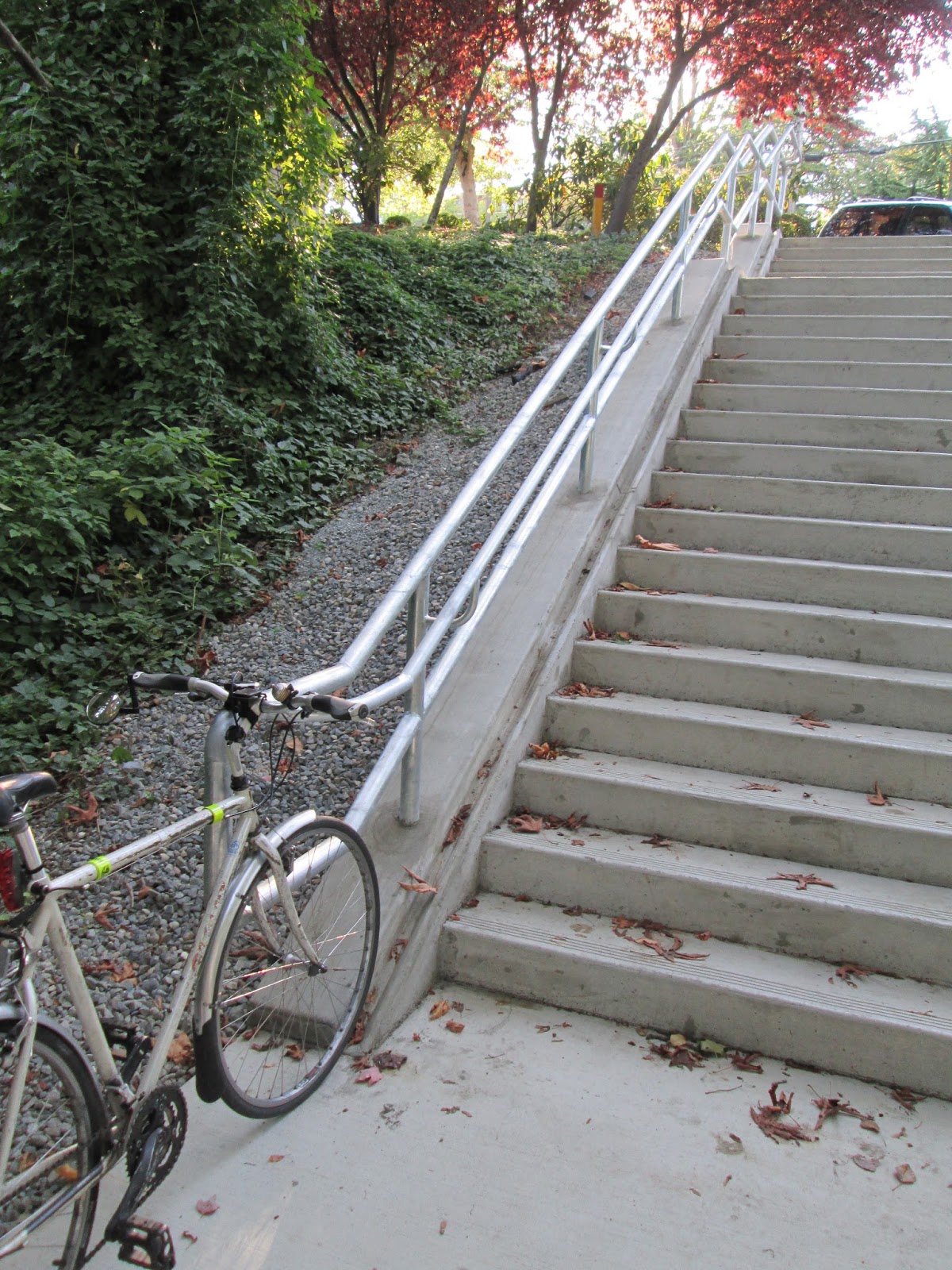
The long staircase that takes East Thomas Street across Madison between 25th and 26th has been rebuilt, and I was excited to see that a runnel for bikes was added.

But does this really make it easier to get my bike up the stairs?

I have seen pictures of runnels (also knows as bicycle stairway channels), notably in bike-friendly Copenhagen, but I hadn't ever tried to use one.  So today I took my bike over to the newly rebuilt stairway and tried out the runnel.

I'm sorry to say I'm disappointed. 

First of all, there's only one runnel, on the left side of the staircase when going up.  If someone were trying to walk down the stairs, with or without a bike, while I was going up, we would run into each other.  That's a minor problem, since there isn't a huge amount of traffic on that stairway.

More annoying, the metal railing is very close to the runnel and is just at the height of my handlebars.  My handlebars catch on the railings on the landings, my mirror gets whacked out of alignment, and my pedals catch on the support posts unless I lean the bike over as I push the bike up the runnel.

I didn't have a pannier on my bike for this visit to the runnel, but a load of groceries would make it even harder to avoid getting caught up on the railing.  

For anyone with a shorter bike, or with drop handlebars, or a fat well-loaded pannier, this runnel will be extremely difficult if not completely useless.

In summary, nice try, SDOT, but please take a bike up and down the Thomas Street runnel before you design the next one.

Friday, July 5, 2013

Bikes Are Just Like Cars

I see complaints from time to time that people who ride bicycles don’t behave just as if they were driving cars.  I know, the law says bicycles are the same as cars.  But when I think of comparisons between bikes and cars, I can’t come up with any (other than the penalty the operator will receive for disobeying the “rules of the road”) in which bikes and cars come out roughly equal.  

Here are some possible comparisons:

  • Space vehicle occupies on the road
  • Ratio of driver’s weight to vehicle weight
  • Distance the vehicle will travel if the operator falls asleep or dies
  • Risk that vehicle will go up in flames if it crashes
  • Maximum speed
  • Typical speed
  • Ability of vehicle operator to remove the vehicle should a person become trapped under the vehicle
  • Distance the vehicle operator can carry the vehicle if the vehicle becomes disabled

Officer's Car Crashes into Building, Seattle P-I, 1/30/2007
I’ll give you a gold star if you can think of one where bikes and cars come out roughly equal.

Monday, June 3, 2013

Safe Routes to Health, Part 3: Small Nag, Positive Change

If you're looking for a way to change the world that doesn't take a whole lot of effort and is reasonably likely to get results, check out the "directions" or "how to get here" page on the website of your favorite organization. Chances are, even if the organization is a bike shop or a non-profit devoted to combating climate change, the website will give detailed directions for people who drive cars, but will not offer any useful information for people who ride bicycles, use public transit, walk or use wheelchairs.

The webmaster for your favorite organization - most likely a young person who may not even have a driver's license - will respond quickly and positively to your suggestion to post more inclusive, less car-centric directions.

I've done this kind of nagging for years, but I never thought to save examples of how the websites looked before the update.  Thanks to my friend and Seattle Neighborhood Greenways organizer Cathy Tuttle, I can now show "before" and "after" screenshots illustrating her successful nag.

Cathy checked the website of the UW School of Public Health, an institution that has been a leader in promoting active transportation as an essential contributor to individual and collective health.  Here's the screenshot she saved of the "before" directions page:


Note many paragraphs of turn-by-turn directions and detailed parking instructions for drivers coming from every imaginable location - and not a word about buses or bikes.

Now here's the "after" directions page (this is a screen shot; visit the actual page here):


Here's a detail shot of the walking and cycling information.  In the live page, the underlined links lead to further specifics about walking and biking around the UW.


And here's a detail shot of the transit information.  Again, the links lead to further specifics about bus routes and schedules.


What happened to all those paragraphs of driving directions?  Gone - now there's just an invitation for people to figure out their own driving directions following a link; and you have to scroll through all the walking, biking and transit information to find this:


Very positive change from a small nag!

Tuesday, March 5, 2013

My doctor tells me to drive!

I visited my long-time primary care doctor the other day for my Welcome to Medicare physical.  I arrived by bike, of course.  My doctor tells me my bike riding is keeping me healthy.  Then why do I say my doctor tells me to drive?

From the time when I made my appointment until I rode away on my bike, I received many messages from my doctor telling me that I should be driving.

1. On the web: I go to the Group Health website to find directions to the Capitol Hill Clinic and find this map:

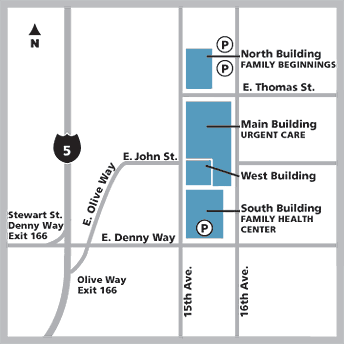
The map shows the freeway and the arterial roads near the medical center, and it features big bold circles showing me where I can park a car. It offers no information of any use to me if I arrive by bike or by bus: it doesn't show bike routes, bus stops, sidewalks or crosswalks. 

Below the map are three paragraphs of detailed, turn-by-turn instructions for driving to the clinic from the freeways, and a sidebar details parking rates. There is no mention of biking or walking routes to the medical center, and no mention of bike parking, 

There's a link labeled "elsewhere on the Web" connecting to Metro Transit's Trip Planner, but you have to follow the link to discover the three bus routes that serve the medical center. 

Through this web page, my doctor tells me that driving is the best way to get to the clinic.  If I choose any other means of transportation, I'm on my own.

2. When I arrive at the clinic, I see big signs at each approach to the building telling me where to find car parking.  To find bike parking, I have to search the grounds (see my earlier post for more about bike parking).  I happen to know there's a bike parking area in the garage, but there's no sign to tell me where to find it.  The outside of the building tells me I should be driving.

3. When I'm ready to leave, I find bold signs inside the building pointing me to the parking garage.  If I had arrived by bus, I would not find any signs reminding me where to find the bus stop or telling me which buses serve the clinic.  If I look closely at one of the big facility maps on the wall, I can find a small icon indicating bike parking - but there's no icon for the bike parking inside the garage.  The inside of the building tells me I should be driving.

I'm using Group Health as an example, since that's where my doctor works. I suspect you'll find similar messages encouraging driving wherever you go for healthcare.

My doctor tells me I should stay active.  Your doctor probably wants you to stay active too. The websites our doctors use and the buildings where our doctors work should be reinforcing that message, not telling us we ought to drive.


Sunday, December 30, 2012

Safe Routes to Health, Part 2: Riding a Wheelchair to Health

Terry and Vickie Hoefer running (LEE GILES III/The Peninsula Gateway)

In Gig Harbor, you can get to the local Starbucks in a wheelchair - but not to the local hospital. Can this be true?

A few days ago, I noticed this headline in the Tacoma News Tribune:  Wheelchair training along roads in Gig Harbor area creates a stir.  Terry Hoefer, a young man who uses an electric wheelchair for mobility, has been training for a marathon, driving his wheelchair along the roads of Gig Harbor accompanied by his mother Vickie, who runs alongside. His dad followed in the car, blinkers flashing. Terry trains in order to build up the strength and endurance to sit upright and operate the wheelchair controls for the long duration of a marathon.  Training was going fine until the family was pulled over by the State Patrol for "obstructing traffic."  It turns out the laws governing electric wheelchairs on roadways are confusing and restrictive:
“Basically, we can ride on the designated bike lanes all over, but we can’t ride on a street that doesn’t have a white line,” [Terry's mother] learned this month.
This means Terry's training route needed modification:
Pierce County helped make a local sidewalk wheelchair-accessible, which means they can still run along Burnham Drive Northwest to the local Starbucks, one of their favorite outings. They’ve stopped using another route, to St. Anthony Hospital, because it doesn’t have a legal shoulder or bike lane. Terry Hoefer has spent a lot of time sick at St. Anthony, and it was fun to see him healthy there on their runs, his mom said.
This story is sad and shocking on so many levels.  Why does a person who uses a wheelchair have to study obscure laws and prevail on local authorities just to make a trip out in the community?

And how is it that you can ride a wheelchair to the local Starbucks - but NOT to the local hospital?

Mobility is essential to health.  Everyone who works in that hospital knows that's true.  Shouldn't everyone be able to get to the hospital - or wherever they want to go - on their own power, whether it's walking, rolling in a wheelchair, or riding a bike?  I hope St. Anthony Hospital takes a look at what Children's Hospital in Seattle has done to create safe routes for walking, biking and wheelchairs near the hospital!

I can relate to Terry's story on another level as well.  I've been caring for my mother-in-law, who needs a wheelchair to get around outside the house.  A few days ago she read in the newspaper about the grand opening of the relocated Museum of History and Industry.  "I'd love to go!" she told me.  So we went.

I helped her into her wheelchair, wheeled her down the street to the bus stop, rolled the wheelchair onto the bus, transferred to the South Lake Union Trolley, and got off half a block from the museum.  We had a great time.  This trip didn't involve any exercise for my mother-in-law - I pushed the wheelchair - but it gave her a chance to be out in the community.  She loved the misty rain on her face and the bustle of the crowds at the museum. And for me, the caregiver, it was a refreshing opportunity to get some exercise and have a change of scene.

I'm sure that Terry's mom benefits as much as Terry does from their outings together. Isolation and lack of exercise are huge challenges of caregiving.  Streets that are safe and accessible for people in wheelchairs are critical for the health of caregivers, too.

Thursday, December 13, 2012

Hey Drivers! Did you know you're supposed to YIELD to buses?

Mike Siegel/The Seattle Times
Dear Seattle Times

I'd like to thank your reporter Mike Lindblom for pointing out that bus bulbs are necessary because people who drive cars so frequently fail to yield to buses as the law requires.

Shortly after reading this article, during a 15-minute drive across Capitol Hill, I observed the following:

- a person driving south on 15th Ave. East attempted to pass the #10 bus as it pulled into traffic on 15th. The driver eventually pulled back to avoid crashing into the bus.

- a person driving south on 16th Ave. E. turned left onto eastbound East Thomas as a #43 bus started to pull out from a stop. The driver took up the entire westbound lane to get around the bus, causing oncoming traffic to abruptly stop.

- as the #11 bus dropped off passengers at 23rd and Madison, a person driving a taxi pulled around the bus, crossing the double-yellow center line to do so. Six more people driving cars followed the taxi as the bus started to pull out.

I should mention that I did observe one person driving a car who did in fact yield to a bus. 

Sincerely,
The Transportation Nag